

Hello, welcome, come aboard. We’ve been at this grand tour for a year now. It’s been a whirlwind of adventures, fun, family milestones and new friendships. If, as they say “life is what happens when you’re not looking” then I’d love see what we’re missing. I have three other blogs half done but I am putting them aside to tell you of our most recent sailing adventures through the Dardanelles Strait on our way to Istanbul . (Sorry folks, I’ve written an essay: I’d call it a leisurely Sunday morning read over a long coffee and maybe a croissant.)
This place is the heart of history: ancient and modern. All of it incredibly interesting and relevant. When we were planning our life on a boat and talking about the places we would go, the Dardanelles held a dual fascination. Especially for Ian as it’s the heart of the ANZAC tradition and a sailing challenge in terms of prevailing winds and currents.
Here too, near the Aegean entrance to the Dardanelles, lays the ancient city of Troy, as immortalised in history, myth and legend. I’ll try to get to some historical aspects in future blogs, but we’re finding the depth and breadth of Turkish history a little overwhelming. As an example, recently archaeologists discovered a temple and ancient city at Gobekli dated at 10000 years BCE, that’s 6000 years before Stonehenge! This discovery is challenging our understanding of human development in terms of societal structure and technology.
This blog, however, is all about the sailing. Honestly, we mostly motored for this passage as sailing is prohibited within the Dardanelles and the winds were against us but let’s not quibble over the semantics.
Those on FB will know that on 19 June 23, we tackled the Dardanelles Strait. The Dardanelles are a narrow, natural strait once known as Hellespont and now officially called the Çanakkale Boğazı in Türkiye. The Dardanelles together with the Bosphorus Straits, are called the Turkish Straits. This is where “East meets West” in the city of Istanbul and the waterways are gateway to the countries of the Black Sea.
The Dardanelles is a naturally zig zag 61km waterway. The narrowest section is just 1.2 km wide is just 55metres deep though in other stretches the depth plunges to 338 metres. The Straits have two opposing currents: a surface current flowing in from the Black Sea (via the Sea of Marmara) towards the Aegean Sea (against us) and a heavier saline undercurrent flowing from the Aegean Sea into the Sea of Marmara. The current speed can reach up to 3.5 knots. Making it a significant maritime challenge especially for smaller sailing vessels with cruising speeds around the 7 knots (like us). We now have some inkling of how Sisyphus* felt. This, combined with an all or nothing prevailing head wind makes weather planning crucial to ensure you have the right conditions for your run up the Dardanelles. (*the poor sod charged with pushing a boulder up hill everyday for eternity. Every night the boulder would roll back down)
To further the complicate the already tricky cruising conditions, the Dardanelles (together with Bosphorus Straits) are the only sea route between the Mediterranean and the Black Sea. They are critical for the transportation of goods to and from Bulgaria, Romania, Moldova, Ukraine, Russia and Georgia. Consequently these waterways are among the busiest in the world.
As our friends and sailing companions for this trip, Janine and Craig on SV Inelsamo told us the Dardanelles are “considered one of the most hazardous, crowded, difficult and potentially dangerous waterways in the world.” So not your average Sunday cruise around the bay!
A quick pitstop to introduce Janine & Craig and their lovely yacht, Inelsamo. As sailing buddies go we couldn’t have asked for better than these Aussies. They have loads of sailing experience, stories galore and Janine makes a mean Spaghetti Bolognaise. They have generous hearts and are willing to share their advice, time and adventures with us. Just as well since we often have very little idea of what we’re doing.

2. The crews of Inelsamo and Longo Maï
We began our day well before sunrise at the Bozcaada Island municipal dock. It’s that lovely time of the day when the sun’s blush races ahead to soften the pre-dawn darkness. In the distance we could see the cargo ships lining up to take their position in the conga line that would wind through the Straits shipping lane throughout the day.
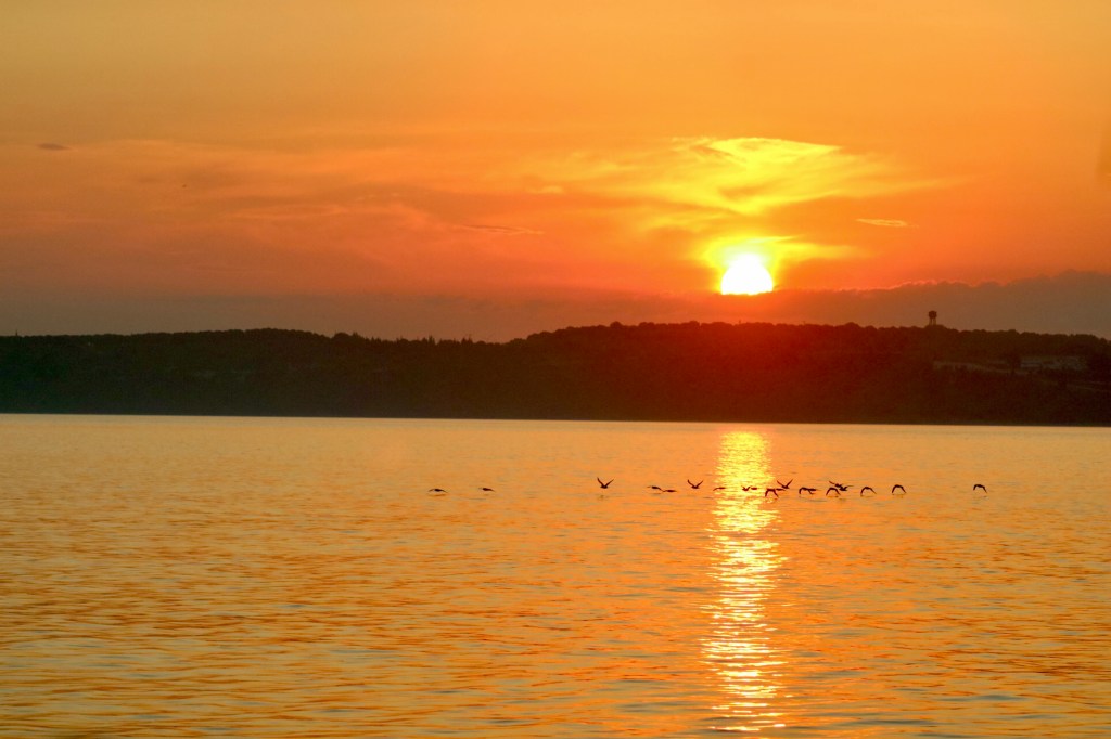
The trip from Bozcaada to the mouth of the Dardanelles is about two hours. There was only the tiniest ripple of imperfection on the water and barely a breath of air, so the sailing was easy. This gave us time for a much needed coffee, so I left Ian and Brittany (our autopilot, because Brittany Steers) on watch and headed down to the galley. Thankfully I was back on deck as the sun rose over the Eastern shore. I have 40 or so photos of this sunrise but will only inflict the very best one on you. Poor Ian, he had to listen to me prattle on about this sunrise while trying to enjoy his coffee and man the helm.
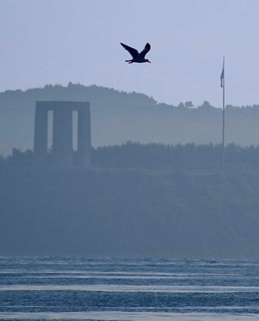
The historical significance of this region hit home, shortly after as the first and largest monument in the region appeared on our horizon. The Çanakkale Martyr’s Monument memoralises the service of the 253,000 Turkish soldiers who participated in the battle for Gallipoli. Being reminded of the noble husbands, loyal fathers and frightened sons (no doubt there were some daring daughters as well) that lost their lives on the Gallipoli battlefields was an arresting pause in our otherwise exuberant excitement for the day’s adventure.
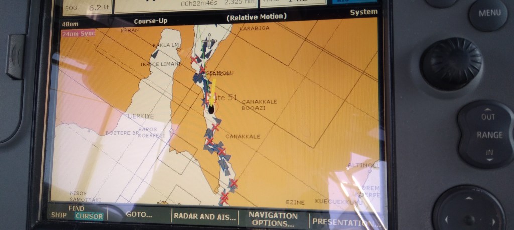
Shortly after passing the monument we entered the Straits and began to experience, for the first time, the current that we would compete against for most of the day. Our speed slowed as our boat’s engine pushed against the water escaping the Marmara Sea through the funnel that is the Dardanelles. In the photo of our chart plotter you can see our SOG (speed over ground) is 6.2 knots, as I mentioned we average 7 knots when motoring. Through the narrowest section we could only manage 3.5 knots thankfully this lasted only a few minutes.
There are two options for tackling this challenging current. The first is to stick to the 10 metre depth line where the current is weaker. This option means following the natural contours of the straits. The second option is to set a straight line path which includes some deep water stretches. The first option means a longer distance is travelled but the current’s effect on SOG is less. The second option means at times there is more drag from the current but overall distance is less. The different routes affect diesel consumption, time taken and… this is the point where my eyes glaze over because… well… math! To test the theory Inelsamo took the shallow water option, Longo took the straight line approach. Not that anyone was competing or anything but we’ll never know who was more efficient, as our boats have unique characteristics. However, from my perspective, the important distinction was that we were much closer to the action of the shipping lanes. While Craig and Janine were treated to a closer view of the beautiful landscape. Both worthy and made for great conversation over dinner.
The ships and boats operating within the straits are highly regulated with designated shipping lanes defined electronically. While smaller vessels, such as Longo, are confined to the edges, supposedly well clear of the monster ships. Imagine a big blue wet wobbly highway but there are no visible lane markers except those on your map. We heard constant radio chatter between ships (with varying accents) and, the Turkish pilot boats and the coastguard. Much of this was about the activities of the dozens of pilot boats zooming around the ships delivering and retrieving pilots. Watching the transfer of a pilot from a small boat to a ladder hung over the side of a huge ship makes those scenes in action movies where the hero jumps between moving cars quite humdrum in comparison.
The only time small boats are permitted in the central shipping lanes is when crossing “the road”. This maneavure takes precision timing to find a gap in the traffic big enough to accommodate our slower speed and the affect of current on the boat. We crossed over towards the end of our passage to reach our anchorage. So I now know how a slightly arthritic and near sighted echidna feels as it tries to cross the Bruce Highway on the first Saturday of Easter holidays!
Along the way we saw a dolphin pod playing, plenty of local fishing boats that make our Longo look massive, whirlpools big enough that we felt their affect on the boat’s performance, and ferries making the dash across the strait between traffic. Thankfully, we didn’t sight the illusive Porphyrios.
Another brief interlude to introduce Porphyrios. Porphyrios was a large whale that harassed and sank ships in the waters near Constantinople (as Istanbul was then known) in the sixth century. Active for well over 50 years, this mega-ton murder fish was more than a bit of a bother for Byzantine seafarers. He was such a nuisance that Emperor Justinian I (r. 527– 565) declared Porphyrios’s demise a State Matter, but it seems no one could catch or kill this elusive beast. Eventually, Porphyrios beached himself near the mouth of the Black Sea chasing a dolphin snack and the locals took the opportunity to have a mammoth cookout on the beach! True story! (So orca’s chomping on boats rudders is definitely not a new thing)

We did see a hooligan ship captain overtake another ship on a narrow curving section of the strait. Overtaking is prohibited and the captain being overtaken made his displeasure quite “vocally” over the radio. It was the gutsiest, and stupidest, move we’ve ever seen. The slightest misjudgment would have risked a collision in a narrow waterway with no room for evasive manoeuvres. The overtaking boat was going so fast it created quite an impressive bow wave, which one brave dare-devil dolphin used to perform impressive leaps into the air. Unfortunately this all happened close enough to us that we changed our course to avoid being the “bug on the windscreen” and so I was too busy to take photos or video!
We were also challenged when the wake of another ship passing over shallower water resulted in steep white capped waves. As we were travelling parallel to the ship these waves were coming at us from the aft portside (back left hand side). Initially we were just going to ride this out without altering course as we had for other ship wakes. However, Ian looked back to see Inelsamo (a 52’ boat) turn into the waves. After watching Inelsamo launch its bow skyward before burying its nose into the next wave, we thought discretion is definitely the better part of valour and turned to meet the waves head on as well instead of risking swamping our cockpit.
Another treat this journey had in store for us was our first bridge underpass. The “1915 Çanakkale Bridge” is named in honour of the Turkish naval victory against the British, French and allied navies during WWI. It is the longest suspension bridge in the world with a total length of 4.61 kms and a main span of 2.02 kms. Though, for us, it wasn’t its length and engineering magnificence that mattered but its height! After all, our boat is 18 metres high (from the water line to mast pinnacle) and the consequence of touching the mast on a bridge would be catastrophic. We needn’t have worried so much since the bridge is 334 metres above the waterline! So it was never a real issue, but still, I felt a tingle of nervous anticipation as we glided into its shadow.
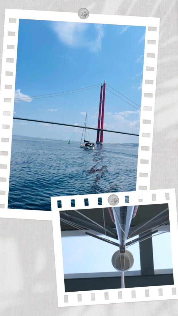
1. Knowing we were a bit thrilled by all this nonsense, Inelsamo followed behind to get photos of our first bridge “crossing”.
2. Looking up the mast at the road above.
After completing our run through the Dardanelles we were expecting a pleasant few hours of easy cruising along the coast of the Sea of Marmara before anchoring for the night. However, the weather gods are pranksters and darkened our horizon with a fast moving storm. Sailors mostly love the wind, we adore the sun, don’t mind rain but we are not terribly keen on lightening. This is understandable given the rather large conductive pole sticking out of our boats while sitting in a big puddle of water! The danger is real but the odds are reasonably low especially if you act appropriately. So after a quick assessment of the radar and a brief discussion between boats about the storm’s likely path, we decided to act “appropriately” and employ the usual tactical defensive action: avoidance. They don’t say “any port in a storm” for nothin’. So we headed into the nearest anchorage for a spell to give the storm time to pass ahead. As I performed my crew duties which invoke working the windlass*, counting chain length and generally keeping watch, while sitting on the deck as far away from all the shiny metal as I could possibly get, I was treated to a front row seat to the weather. Thankfully, the storm was more wet bluster than fireworks (I didn’t see any lightening) and after a short while we upped anchor and continued to our night anchorage. (*anchor lowering do-dah)
After such a long day (12 hours or so underway) we popped over to Inelsamo for a dinner of Janine’s delicious spaghetti and a few wines before dinghying home for a good long sleep. The next day was just as long as we motored along the Sea of Marmara, with even more dolphin, ship and storm watching. We also had some adventures in Grand Petit Bateau, our dinghy, but as there was no damage, no injuries and importantly no video, that story will become a myth that you might be able to persuade Ian to tell you over a G+T sometime.
The last leg of this amazing trip saw us cruising past some of the largest and busiest dockyards in the world including weaving our way through hundreds of anchored cargo ships waiting their turn to dock. At one time we saw 284 targets being tracked on our navigation system. Some ships appeared very tired and used, and at times it felt like a ships’ graveyard. Finally, we crossed the Bosphorus Strait shipping lanes and tied up at the marina that is our home while we explore beautiful and exotic Istanbul. I’II write reams about Istanbul in the days to come.
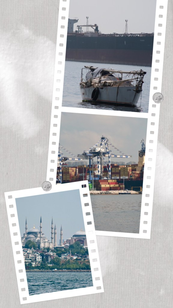
1. Initially we thought this floating junk was abandoned. As we were just heading down to radio the officials to alert them of the potential dangers a weathered hand appeared above the deck to straighten the tarp. A ship-shape boat is after all next to godliness.
2. If you look close enough you’ll see a sailboat much the same size as Longo “hiding” in plain sight in front of the behemoth docks and ship.
3. Our first glimpse of old Istanbul (not Constantinople).
We’ll be returning to the Sea of Marmara and the Dardanelles in a week or so. This time however the current and winds (hopefully) will be with us, so we will take the opportunity to stop along the way and explore the history more. Those posts will be all about the history.
Until next time fair winds and a dearth of sea monsters on your journey ahead. (Odd how appropriate this blessing has become.)

What a wonderful read and thank you to Janine for passing it on to me. She knows how much I like to keep track of where they are, as it gives me such peace of mind! I am seriously envious of you seeing such places, as it was always a dream of mine to visit Turkey and especially Gallipoli but, sadly, age is against me these days. So I will live my dream through adventurous folk such as yourselves! God bless and safe travels. 🤗🙌💕💕💕💕
LikeLiked by 1 person
Thank you for your lovely message. This is certainly a wonderful life! Türkiye is as special place, we are looking forward to our trip to Gallipoli. 😊
LikeLike